Landslide Prone Area Characteristics, Risk Factors, and Warnings
- SMS Broadcaster Admin

- Apr 24, 2025
- 3 min read
Landslides, mudslides, or avalanches are destructive. They can alter environmental landscapes and damage an entire community. However, these catastrophes cannot occur anywhere. Only those with particular features are susceptible to mudflows. What are landslide prone area characteristics?
Moreover, landslide risks in those regions may fluctuate. During particular periods, the disaster risk in a landslide-prone area is exceptionally high. Therefore, governments and their citizens must know those characteristics and risk factors.

Landslide Prone Area Characteristics
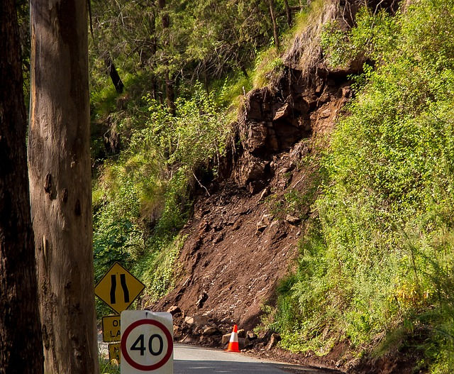
Landslide-prone regions are typically mountainous or sloping. However, not all mountainous areas are vulnerable to avalanches, mudflows, and landslides. Only those that have the following characteristics have a high landslide risk.
Terrain
Experts typically evaluate a landslide risk of a particular area based on its topographic characteristics. Regions with slope angles between 0.5 and 15o are prone to mudflows.
In addition, areas with slope angles ranging from 15 to 35o have a high landslide risk. Moreover, slopes with over 35o have the highest landslide risk.
Other terrains that indicate landslide areas are channels along streams and rivers. Furthermore, slopes with joints and fissures may suffer from mudflows when they are triggered by a particular factor.
Materials
The next landslide prone area characteristic is related to materials found in the slopes. Particular materials can cause mountainous regions to be more vulnerable to mudflows.
Some soil types, such as sand and loamy sand, have a soft texture and are susceptible to instability. Therefore, slopes with those soil types have a high landslide risk.
In addition, mountainous regions with clay and silt have a high mudflow risk because these soil types are easily saturated and unstable. Consequently, landslides are likely to occur in sloping areas with soft and easily-saturated soil types.
Moreover, slopes with loosely packed rocks or weathered rocks, are vulnerable to landslides because they are unstable. Rocks with extensive faulting and jointing can also cause avalanches since the faults and joints allow water to penetrate the soil and create instability.
Human Disturbance
Human activities can turn slopes into landslide high risk locations. Deforestation, bad agricultural practices, construction, and other activities can cause erosion, slope instability, and other environmental damage.
Locations
Slopes located in particular locations have a higher risk of mudflows. For example, sloping areas near rivers are susceptible to mudflows.
When these rivers are flooding, nearby slopes may suffer from erosion or soil instability that leads to landslides. Moreover, slopes in earthquake-prone areas or near volcanoes are vulnerable to landslides because earthquakes and volcanic eruptions can trigger mudflows and avalanches.
Landslide Risk Factors
The landslide risk in a region can increase because of several factors. What are those factors?
Heavy Rains
Many landslides occur after heavy rains. Easily saturated soil will saturate rainwater and increase in weight. Therefore, the soil is not stable and mudflow occurs. In Java, Indonesia, rainfall of 63 mm over 3 days or 30 mm daily can generate landslides.
Earthquakes
Earthquakes, particularly the powerful ones, can trigger landslides. The shake of this disaster can disrupt soil, rocks, and debris in sloping areas and cause them to fall.
Volcanic Eruptions
The weight of ash, rocks, and debris from a volcanic eruption can overload sloping areas. In addition, volcanic activities may disrupt the soil stability. Therefore, the combination of volcanic activities and materials can trigger landslides.
Erosion
Erosion can remove the cohesive elements in the soil. Consequently, rocks, debris, soil, and vegetation cannot be bound into a solid mass. As a result, this earthen mass will fall down the slope easily.
Climate Change
Greenhouse gases, industrial processes, agriculture, and deforestation have caused climate change. This condition can increase the frequency of extreme weather phenomena and alter precipitation patterns. Therefore, landslides have a higher potential to occur.
Warning Signs
Aside from the characteristics above, sloping regions often show warning signs before a landslide occurs. People typically can find those signs after heavy rains and tectonic or volcanic activities. Commonly, signs are new cracks, sinks, and bulges in the ground present before a landslide.
Those signs occur because the ground is shifting. Moreover, this movement may cause water to seep through or spring out of the ground. Other signs of potential landslides are tilting trees, broken pipes, jammed windows, and unusual rumbling sounds.
Landslides are dangerous. Therefore, governments must create a landslide prone area map to mitigate this natural hazard. In mapping the vulnerable regions, they must evaluate the slopes’ characteristics. Moreover, governments must have cell broadcast machines to warn people about potential landslides. These machines are available on smsbroadcaster.com.


appreciate Henry for making me realise the truth to a certified hacker who knows a lot about what he is doing. I strongly recommend you hire him because he’s the best out there and always delivers. I have referred over 10 people to him and all had positive results. He can help you hack into any devices, social networks including – Facebook, Hangout, iMessages, Twitter accounts, Snap chat , Instagram, Whatsapp, wechat, text messages ,smartphone cloning,tracking emails and also any other social media messenger or sites. It’s advisable to hire a professional hacker.Thank me later. Contact him here., Henryclarkethicalhacker @ gmail .com and you can text, call and Whatsapp him on 1(219)7960574.....