Landslides in Indonesia’s Central Java and Its Risk Mitigation
- SMS Broadcaster Admin

- Nov 22, 2025
- 4 min read
Climate disasters have many risks. Landslide is an example. Central Java is the province most frequently hit by landslides. Cilacap and Banjarnegara are disaster areas of landslides in Indonesia's Central Java. Heavy rain that is supported by soil structure and elevation is the causal factor of the landslides.
The Impacts of Landslides in Indonesia’s Central Java
Extreme rainfall is a cause of landslides in Central Java. The soil structure in the highlands changes due to increased water content. Cilacap and Banjarnegara were hit by landslides.
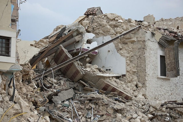
Landslide in Cilacap
A landslide in Cibeuying Village, Majenang, Cilacap, on Thursday, November 13th, 2025, caught many attention. The rescue teams conducted the evacuation process. Right now, this disaster has claimed 18 lives, and five victims remain missing. The rescue team is still being searched for. All survivors were evacuated and placed in refugee areas until conditions returned to normal.
Based on geographic conditions, there are open areas without trees that triggered a landslide. Moreover, a day before the disaster, some residents observed a crack in the ground while climbing a hillside. The type of crack was circular and deep. It is about one meter. Precisely at night, the landslide occurred, accompanied by a rumbling sound. Neck-high mudslides dragged everyone in the disaster area.

Landslide in Banjarnegara
An extreme weather event occurred in Situkung, Pandanarum Village, Pandanarum District. A heavy rain since the afternoon caused the collapse of cliff above the residential area. This disaster happened on Sunday, November 16th, 2025.
The victims consist of three fatalities, 25 people are missing, and 800 refugees. Moreover, damage to facilities occurred everywhere. Buildings collapsed after being hit by landslides. Trees tilted and felled as the ground sank and collapsed.
The rescue team immediately carried out an evacuation after the disaster. Until the conditions were normal, residents were allowed to stay in refugee camps. It is because the ground is still unstable and moves continuously. The land structure is already saturated with water, so there is high potential for subsequent landslides.
The Risk Factors of Landslides
Landslides in Indonesia’s Central Java are the effect of climate change. Floods or earthquakes cause this landslide. Two landslides occurred in Central Java, namely in Cilacap and Banjarnegara, caused by heavy rain in the long term and supported by other factors.
Water pressure in the ground is increased by heavy rain and then shifts the soil mass and triggers the landslide. The increased water pressure is indicated by bulging soil or the emergence of new springs on the surface. This bulging soil causes cracks in the floors and walls of buildings due to the weakening of the soil structure.
The initial signs of a landslide are cracks and rumbling sounds. Other symptoms include buildings, trees, or poles suddenly tilting downward. The event occurred very quickly, trapping many residents. Others had already evacuated to higher ground.
Disaster Risk Mitigation
Disaster risk mitigation is a series of actions taken before, during, and after a disaster. The Indonesian government implements all of these measures for public safety. Landslide risks can also be addressed quickly and even prevented due to advanced prediction.
Monitoring
Routine monitoring is a crucial foundational step. Without it, there's no data on changes in natural conditions that cause landslides. To ensure accuracy, monitoring is carried out using monitoring sensors that consist of tilt meters to detect ground movement, soil moisture sensors to determine water content, rainfall sensors to measure rainfall intensity, and vibration sensors.
Mapping of Potential Landslide Areas
Mapping potential landslide locations is a government risk mitigation program. By this mapping, the landslide potential areas can be detected to support disaster risk prevention. Landslide susceptibility maps become a basis for predicting landslides and other related disasters, such as earthquakes, flash floods, and embankment breaches.
Prediction
Disaster prediction is a basis for risk prevention. Accurate predictions are achieved through precise analysis by experts, supported by the data from monitoring sensors and detectors. All this data is interpreted into information, then analyzed to produce conclusions in the form of disaster predictions. This, of course, requires coordination from all parties.
Early Warning System (EWS)
Before a disaster happens, an early warning system (EWS) is given to inform the public. This system is coordinated with monitoring sensors and expert predictions. In this landslide case, an early alert system is crucial to avoid the risk of being hit by falling debris or land.
Evacuation and Recovery
After an evacuation warning, the evacuation was actually started by the rescue team. This evacuation allows people to escape through predetermined routes. A simulation given before disasters occur is helpful and accelerates the evacuation process in an actual disaster.
The next program after evacuation is recovery, which is immediately implemented to return activities to normal conditions. Various disaster risks are immediately addressed, including physical and mental health, economic conditions, education, etc.
Evaluation
Evaluation is a final step in the risk mitigation program and plays an important role in assessing program effectiveness. The results of this evaluation are used to inform improvements in program implementation or to determine program revisions. Evaluations are conducted periodically.
Landslides in Indonesia’s Central Java are a natural disaster that requires serious attention. In line with disaster risk mitigation programs, very crucial to provide a disaster warning system before a disaster occurs. Besides the sounds of alarms or sirens, an emergency message is needed to provide detailed and clear information.
An emergency message-sending system based on SMS (Short Message Service) needs to be provided by the Indonesian government. It can send an emergency message in real time and spread evenly because it has a wide range of 500 m to 2 km, covering all operators. This specific machine is available at smsbroadcaster.com.


Comments